Meet the neighbours
The Ballingarrane Park is currently occupied by Ballingarrane House, a historic residence in public ownership. “Questum”, a Research, Development and Enterprise Centre developed by Tipperary County Council in 2014 in partnership with Limerick Institute of Technology (LIT) is at the main entrance to the site. Tipperary County Council also occupies an incubation support unit within the site.
TECHNICALITIES
Overview
Ballingarrane Park offers a unique location for strategic enterprise, knowledge intensive and technology based industry and large scale employers to grow and develop in an aspiring environment. Few towns in Ireland possess such an impressive opportunity for companies to grow new enterprise, at a strategic location, in a high quality environment and within public ownership. Ballingarrane Park offers a unique location for strategic enterprise, knowledge intensive and technology based industry and large scale employers to grow and develop in an aspiring environment. Few towns in Ireland possess such an impressive opportunity for companies to grow new enterprise, at a strategic location, in a high quality environment and within public ownership.
Planning Criteria
The planning policy and objectives relative to the subject site are set out under the South Tipperary County Development Plan 2009, as varied (STCDP), and the Clonmel and Environs Development Plan 2013, as varied (CEDP). Policy ED1 (Strategic Employment) of the STCDP states that “It is the policy of the Council to facilitate the sustainable development of strategic employment uses at identified locations subject to the provision of a satisfactory masterplan to be prepared by the relevant landowners(s)/developer(s) for the agreement of the Council”. Section 5.4 (Strategic Development) identifies the lands at Ballingarrane, Clonmel, as a strategic employment area. Under the CEDP the lands are zoned for strategic employment land use.
Ballingarrane Masterplan
This Masterplan builds on the policies and objectives of the STCDP and the CEDP. The purpose of this Masterplan is to set out the vision and physical framework for the development of the Masterplan lands (Map 1) and provide a blueprint as to how this vision can be achieved. It is not an end in itself but a guidance document that sets the long term vision for the project and identifies the initial actions required towards realising that vision. The Masterplan will be used by the Planning Authority to assess planning applications and by developers and stakeholders to guide future development. The Masterplan is intended to provide certainty and guidance to potential investors.
SITE CHARACTERISTICS
Site Access
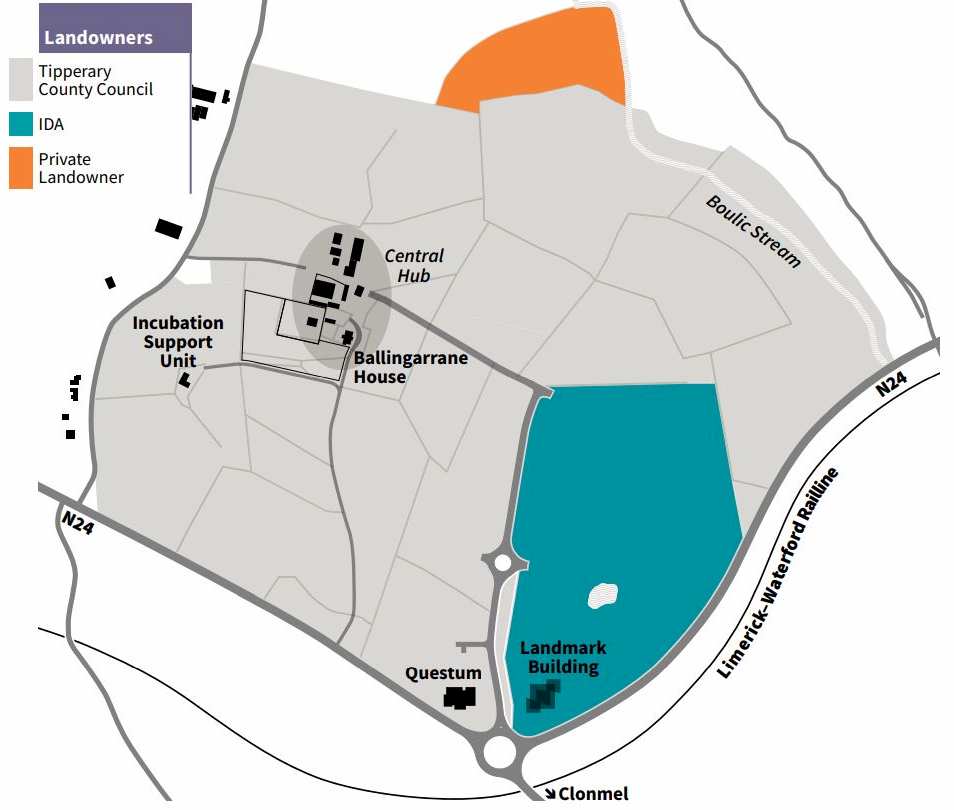
The site is served from the N24 Cahir Road Roundabout by an existing 620m long; 7.5m wide access road with public lighting, footpaths, cycle lanes and internal distributor roundabout. Ballingarrane House is accessed from the N24 by way of its historic entrance and avenue.
Landscape
The estate can broadly be categorised into three landscape character areas. Firstly the house and its associated buildings and garden are surrounded by a mature quality landscape of “Parkland” with picturesque qualities and important views south and eastwards towards the Comeragh Mountains and Slievenamon. Outside this area the landscape is more typically rural in character, comprising larger fields for pastoral and arable agriculture. The third area to the east of the estate is the Boulic Stream and associated steep enclosed valley. The site is well screened with mature planting and with the exception of the Boulic valley is relatively level. Contour/Lidar surveys have been undertaken for the site and can be made available to potential occupants.
Ecology
The site is not located within any Special Area of Conservation, Special Protection Area, or Natural Heritage Area. However, the watercourse that traverses the site flows into the Lower River Suir Special Area of Conservation circa 2.6km to the south east. Marlfield Lake is the closest proposed Natural Heritage Area located 1.2km to the south west. While not a highly sensitive site, the principles underpinning the Masterplan seek to protect the key ecological features of the site and to offset any impacts resulting from its development. It is intended that the river corridors and hedgerows / tree lines will be retained where possible and proposed landscaping schemes for the site – including flood attenuation measures – will enhance its ecological diversity.
Architecture, Archaeology & Heritage
Ballingarrane House, a Protected Structure, (RPS Ref 3), is located centrally on the estate. The house is recorded as having architectural and artistic significance with a Regional Rating on the National Inventory of Architectural Heritage (NIAH). There are a collection of good quality late-eighteenth and nineteenth century outbuildings in a small yard to the rear (west) of the house and forming a larger yard to the immediate north-west. Original features that survive to the present day include the house and outbuildings, the entrance avenue to the south, a walled garden (to west of house) and main historic landscape features of the site are intact. There are two recorded monuments within the site, TS-083-003 (Architectural Fragment within Ballingarrane House) and TS-083-001 (Enclosure within Precinct 5).
Water Quality & Hydrology
There is no water quality monitoring information available for the Boulic Stream. This water course has been subject to considerable engineering works in recent time including culverting and the provision of an off-line attenuation pond capable of catering to a 1:100 year flood. A Strategic Flood Risk Assessment study was commissioned by Tipperary County Council as part of the CEDP which identified lands adjacent to same as being within the 1:100 and 1:100 flood envelope.
Water
Mains Water:
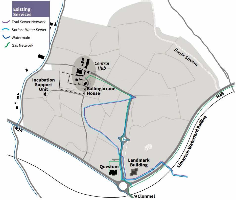
Clonmel Town is currently served by two surface sources located to the south of the town on the lower slopes of the Comeragh Mountains and a groundwater source located north of the town. There is a 150mm PE pipe laid into the estate along the existing access road. The existing infrastructure has the capacity to provide 600m3/day to potential occupants.
Wastewater:
The existing Clonmel municipal waste water treatment plant is located on Davis Road, to the east of the town. The plant has a 55,000 PE capacity (the imposition of a Nitrogen Limit has resulted in a reduction of the 80,000 PE design capacity).
Surface Water:
The site is served by an existing 450mm concrete surface water sewer. Proposals for new development will be required to be supported by SUDS plan and demonstrate that surface water drainage will not exceed 14 litres per second.
Other Existing Infrastructure
Electricity:
There is a 10KV ESB power line serving the site. There is a provisional arrangement in place with ESB Networks to allow for up to 16MVA connection provided via an on-site 38kV substation.
Natural Gas:
There is an existing 125mm medium pressure gas main serving the site.
Broadband:
The Metropolitan Area Network (Direct Fibre Connection) has been laid to the Cahir Road Roundabout. There is currently a connection from same serving Questum and Ballingarrane House.
Public Transport:
The Ballingarrane area is served by the town’s bus service which runs to and from the town centre hourly from 9.00am to 6.30pm Monday to Friday.
DEVELOPMENT GUIDELINES
Land Use
Acceptable land uses within the park are set out under CEDP land use zoning matrix and include for educational, enterprise and employment centre, general industry, and office use as being permitted in principle. Light industrial land use is open for consideration. The above uses may take the form of:
• Stand alone national and multinational industries,
• Business/office/technology related national and multi-national facilities,
• Incubator spaces/suites,
• Grow-on and spin off facilities,
• Research facilities,
• University linked training facilities,
• Support facilities,
• Business support,
• Conference Facilities.
Initially, demand will be low for ancillary support facilities such as retail, amenity, restaurants, etc., and existing nearby facilities offering such services, such as the Park Hotel and the Poppyfields, will have a role to play.
Uses on this site will be focused on those which match the profile of such a high quality environment. Proposed uses should also be clean (both in terms of appearance and emissions), compatible and complimentary of high environmental and amenity qualities of the Park, should be of high quality contemporary architecture (promoting renewable energies and other green technologies where possible) and suitable for integration into a campus style layout utilising the existing levels and topography of the land. Uses which require external outdoor storage, low quality architectural buildings or produce extensive airborne emissions will not be favourably considered on the Masterplan lands and will be directed to industrially zoned lands within the County. Any planning application will be required to include full details of the proposed use, including processes involved and materials and chemicals etc used.
Parkland Characterisation:
The Masterplan site offers significant opportunities to create a visually interesting, inspiring and functionally efficient environment in which to work whilst also adding to the recreational space within Clonmel. The existing landscape is not defined by a single characteristic, but has a varying landscape language that can be developed upon. It is critical to retain a memory of what that landscape was, in visual and functional terms, while also creating a modern and efficient layout. This will inform the development of the brand, effective promotion of Ballingarrane Park and the quality of experience of the users thereafter. Within Ballingarrane Park, it is a goal of this Masterplan to ensure that the Park is a place dominated largely by people, not vehicles, whilst creating large scale employment opportunities. It is intended to create a series of formal and informal walks and civil spaces for interaction, while still allowing for circulation by public transport buses, shuttle vehicles, access for persons with disabilities, construction and emergency vehicles, as well as facilitating practical private vehicle access.
Access
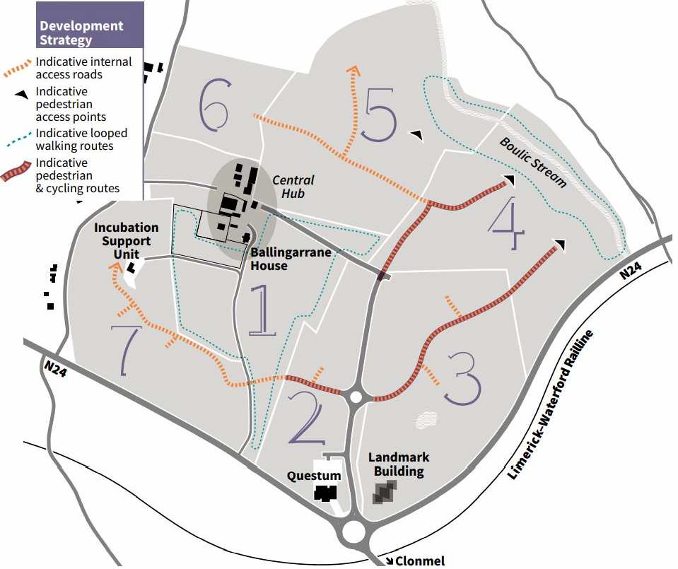
The Masterplan lands are to be accessed from the existing 7.5m wide access road provided from the Cahir Road Roundabout on the N24. No new access points will be permitted from the N24. There will be one main spine road through each precinct only. New access roads provided within the estate shall have a minimum carriageway of 7.5m with 1.3m wide grass strip and 2m wide footpaths and cycle paths. Entrances onto said access roads shall meet the sightlines requirements set out under Section 9.21 of the CEDP.
Precinct Layout
Precinct layouts will be required to ensure that the precinct adheres to the Masterplan vision, strategy and principles. They should include for an integrated approach to land use and utilise the existing levels and topography of the land in the siting of buildings in creating places of human scale. Layouts shall ensure visual and operational co-ordination with adjoining buildings / precincts with high quality connectivity for pedestrians and cyclists, while minimising the use of the private car. Existing natural/cultural features and biodiversity shall be enhanced. Precinct Layouts shall also demonstrate compliance with the standards set out under Section 9.30 (Industrial Development) of the CEDP. Development proposals may be submitted for part of a precinct. In such circumstances a layout shall be submitted for the entire precinct demonstrating that the proposed development does not prejudice the development of the remainder of the precinct in an integrated and cohesive manner. Development proposals may also propose the development of more than one precinct
Precinct Design Scheme(s)
Each precinct will be subject to an overall design scheme which shall set out the proposed design approach to be applied throughout the entire scheme. Design schemes will adopt innovative design approaches suitable for their location and implementing uniform and complementary approach to materials and finishes.
Renewable Energy & Sustainable Building Design:
Tipperary County Council will facilitate and encourage sustainable development proposals for alternative energy sources and energy efficient technologies within the Ballingarrane Park in accordance with Policy INF 9 (Renewable Energy), Section 5.7 (Small Scale Wind Energy Production), Policy INF 10 (Auto Producers of Wind Energy) and Section 9.18 (Sustainable Building Design) of the CEDP.
Phasing
Precincts 1, 2, 3 and 4 are currently served by the existing internal distributor road together with water, waste water, electricity, gas infrastructure and broadband and are available for development in the short term. Where proposed developments require in excess of the 600m3 /day available within the existing water network, developers will need to provide for on-site bored well supply. A functioning hub forms the springboard for a science park to develop. The Community and Enterprise Section of Tipperary County Council in addition to the Local Enterprise Office (LEO) are currently based in Ballingarrane House and offer a one stop shop in terms of enterprise assistance for future park occupants. In the coming years Tipperary County Council intend to progress the development of a further 5,000 – 7,500 sq m within Precinct 1 to include for park management facilities, incubation units, university facilities, first tenants etc. The development of Precincts 5, 6 and 7 is dependent on the extension of the existing site services to serve same.
Parking and Loading
Development proposals will be required to provide parking and loading facilities in accordance with the standards set out under Section 9.20 (Parking and Loading) of the CEDP. The use of grouped or shared parking and loading facilities may be considered acceptable by the Planning Authority in appropriate circumstances.
Landscaping
Precinct plans are required to be supported by a landscaping plan. The Council will require the use of native species in all new planting proposals. Hedgerows should be in hardwood using a mix of elder/dogrose/ blackthorn/holly/hawthorn. Shrub planting should be selected from a mix of holly, elder, green (wild cherry), hawthorn, blackthorn, dogrose or hazel. Tree species should be selected from indigenous species such as oak, ash, silver, birch and rowan. Applicants must demonstrate that satisfactory arrangements have been made to secure the maintenance of all landscaped and amenity space in perpetuity. Such arrangements shall be provided for as part of any planning application.
Environmental Impact Assessment & Habitats Directive Assessment:
Environmental Impact Assessment (EIA) will be required where proposed uses are above the threshold for an EIA as set out in Schedule 5 of the Planning and Development Regulations 2001, as amended, or where the proposal is likely to have a significant effect on the environment, having regard to the criteria set out in Schedule 7 of the Planning and Development Regulations 2001, as amended.
Cycle Facilities
Proposals should provide for cycle facilities in accordance with Section 9.21 of the CEDP and same should be identified at the Planning Stage.
Directional Signage:
Signage shall be restricted to a single sign at the entrance to a precinct identifying all occupants within same. Fingerpost signs will be permitted at junctions within the Park where considered necessary by the Planning Authority.
Boundary Treatment
A comprehensive boundary treatment shall form part of the precinct design scheme referred to above. Boundary treatment between the precincts must be of a form and layout that achieves seamless integration between the precincts, is attractive, encourages mobility, assists the innovation process and contributes positively to the environment of Ballingarrane Park.
Hard Landscape Elements
Hard landscape materials largely include paving and street furniture elements (such as seating, signage, bins, etc). A selection of hard landscape elements should be identified and chosen on the basis of durability, aesthetic quality and its suitability to the Masterplan area
Development Contributions
The Tipperary County Council Development Contribution Scheme 2015 – 2019 is available for viewing at www.tipperarycoco.ie . Section 10 (Exemptions and Reductions) provides for a 30% reduction on development contributions where it is considered by the Planning Authority that the development constitutes economic development on lands zoned for commerce/industry/ enterprise and/or economic development.
Strategic Environmental Assessment and Appropriate Assessment
The Ballingarrane Masterplan 2018 was subject to Strategic Environmental Assessment (SEA) and Appropriate Assessment (AA) screening. Copies of the screening documentation are available to view on request.
Development Contributions
The Tipperary County Council Development Contribution Scheme 2015 – 2019 is available for viewing at www.tipperarycoco.ie . Section 10 (Exemptions and Reductions) provides for a 30% reduction on development contributions where it is considered by the Planning Authority that the development constitutes economic development on lands zoned for commerce/industry/enterprise and/or economic development.
Strategic Environmental Assessment and Appropriate Assessment
The Tipperary County Council Development Contribution Scheme 2015 – 2019 is available for viewing at www.tipperarycoco.ie . Section 10 (Exemptions and Reductions) provides for a 30% reduction on development contributions where it is considered by the Planning Authority that the development constitutes economic development on lands zoned for commerce/industry/enterprise and/or economic development.
Strategic Advantage
The lands are zoned for Strategic Employment land use and are considered to offer a unique location for strategic enterprise, knowledge intensive and technology based industry and large scale employers to grow and develop in a high quality and dynamic environment
Site Maps

PLANNING GUIDELINES
Development Contributions
The Tipperary County Council Development Contribution Scheme 2015 – 2019 is available for viewing at www.tipperarycoco.ie. Section 10 (Exemptions and Reductions) provides for a 30% reduction on development contributions where it is considered by the Planning Authority that the development constitutes economic development on lands zoned for commerce/industry/ enterprise and/or economic development.
Strategic Environmental Assessment and Appropriate Assessment
The Ballingarrane Masterplan 2018 was subject to Strategic Environmental Assessment (SEA) and Appropriate Assessment (AA) screening. Copies of the screening documentation are available to view on request.
Intended Uses/Occupants |
Site Specific Requirements |
| Administrative/Management operations, networking facilities, start up/innovation units’ central open space/recreational facilities. |
Outbuildings to the rear of the Main House to be retained. • Walled Garden & Ornamental Garden to be kept free from development. • Lands to the south of the ornamental garden to be used as playing pitches etc. |
| As per Section 4 (Development Guidelines). | • Any development proposal to include for an Architectural Heritage Impact Assessment concentrating on the relationship between Ballingarrane House and its setting and the impacts of the development on same. Any development shall be cognisant of the findings of the Architectural Heritage Impact Assessment • A landscape assessment shall also be submitted in support of any application on these lands. |
| As per Section 4 (Development Guidelines). Presents opportunities for National/Multi National seeking a significant site with a presence on the N24 National Primary Route. |
• Landmark building to be provided at the entrance to the Park. • Existing Water Feature to be retained. • Cycle and pedestrian routes to be provided through the site into Precinct 4 |
| As per Section 4 (Development Guidelines). | • 6.4 ha to be developed for amenity uses • Applications on lands identified as risk of flooding to be supported by a Site Specific Flood Risk Assessment. • New development shall be designed and sites to ensure no negative impacts accrue on the residential properties on Glenconnor Road. • Cycle and pedestrian connectively to be provided through the site to Precincts 3 & 5 |
| This Precinct will deliver more modest bespoke sites which enjoy the benefits of being located within a Business Park. |
• Development in this Precinct to complement Ballingarrane House both functionally and architecturally. |
| As per Section 4 (Development Guidelines). | • 20m buffer to be provided to the west side of the historic avenue. Mature trees within this buffer to be retained. • New access road through the site will traverse Precinct 1 (Public Park) and must be sensitively designed to complement parkland area. |
Ballingarrane Masterplan
This Masterplan sets out the vision and physical framework for the development of the Masterplan lands in order to provide certainty to prospective occupants.